Faites une randonnée
Les meilleures randonnées près de Seattle
L'automne est l'une des meilleures saisons pour faire de la randonnée dans le nord-ouest.
Les sentiers de la région offrent un spectacle magnifique, avec leurs feuillages automnaux aux couleurs vives qui viennent compléter nos arbres à feuilles persistantes emblématiques. De plus, les températures plus fraîches vous permettront de ne pas souffrir de la chaleur pendant votre randonnée.
Randonnées dans ou près de la région de Seattle pour débutants :
Pour une balade parfaite en début d'automne, rendez-vous à West Seattle's Alki Beach Park, une longue bande de plage qui s'étend d'Alki Point à Duwamish Head (un site emblématique qui surplombe Elliott Bay). Tout au long de cette promenade de 4 km, vous profiterez d'une vue panoramique sur Puget Sound, les montagnes Olympiques et les gratte-ciel du centre-ville de Seattle. Commencez au Jack Block Park, contournez la pointe à Anchor Park et dirigez-vous vers le phare d'Alki Point.
Longueur : 2,5 miles
Distance de Seattle Southside : 14 miles
Coal Creek Trail
À l'est de Seattle Southside, le Cougar Mountain Park offre plus de 35 sentiers bien entretenus qui serpentent à travers les forêts, les zones humides, les falaises et les grottes. Le Coal Creek Trail est un sentier de randonnée forestier très prisé qui regorge d'artefacts historiques, de cascades et de ponts en bois. Suivez le sentier qui descend dans un ravin profond, passe devant d'anciens puits de mine, des traverses de chemin de fer et d'autres vestiges de l'exploitation charbonnière de la fin du XIXe siècle. Le dénivelé n'est pas très important, c'est donc un bon choix si vous ne voulez pas trop vous fatiguer.
Longueur : 9,6 km aller-retour
Distance depuis le sud de Seattle : 21,7 km
Parc Grand Ridge
Le Grand Ridge Park comprend 11 km de sentiers panoramiques qui serpentent à travers des forêts de cèdres rouges de l'Ouest. Cette zone sauvage de 526 hectares est située juste au nord d'Issaquah et du lac Sammamish, et est ouverte aux randonneurs, aux vététistes et aux cavaliers. L'un des points forts du sentier est un magnifique pont de 12 mètres de long, construit à la main, qui enjambe Canyon Creek.
Longueur : 14 miles
Élévation : 1,100 feet
Distance de Seattle Southside : 25 miles
Des randonnées avec vue non loin de Seattle
Granite Mountain Trail
Le sentier Granite Mountain Trail est le chemin qui mène au sommet le plus fréquenté du corridor Snoqualmie Pass. Même s'il est un peu difficile pour les mollets, la vue à 360 degrés sur le mont Rainier et le Snoqualmie Pass vaut largement la peine de gravir les 3 800 pieds (1 158 mètres) en 4,3 miles (7 km).
Longueur : 8 miles
Élévation : 3,800 feet
Distance de Seattle Southside : 52 miles
Sentier du lac Pratt
Le lac Pratt, près du col Snoqualmie, est idéal pour cette saison de transition, et le sentier Pratt Lake Trail est parfait pour accéder à des lieux de pêche, faire de l'escalade et emprunter d'autres sentiers de randonnée. Au total, cette randonnée aller-retour de 13 km traverse la forêt et quelques pentes rocheuses, offrant des vues sur les montagnes, des prairies fleuries et une forêt ancienne.
Longueur : 8 miles
Élévation : 2 300 pieds
Distance de Seattle Southside : 52 miles
Wallace Falls
Situées sur le versant ouest des montagnes Cascade, les chutes Wallace Falls offrent une série époustouflante de neuf cascades, dont la plus haute culmine à 80 mètres. La randonnée aller-retour s'étend sur 8,8 km et emmène les aventuriers à travers des forêts anciennes de conifères, le long de rivières au débit rapide, avec des vues panoramiques sur les montagnes et une faune abondante tout au long du parcours. Bien que les chutes soient magnifiques toute l'année, les habitants recommandent de les visiter un jour de pluie, car chaque goutte d'eau alimente la rivière Wallace, amplifiant la puissance et le spectacle des torrents en cascade.
Longueur : 5,5 miles
Élévation : 1,200 feet
Distance de Seattle Southside : 55 miles
Le Mont Si
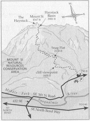
Le mont Si est une randonnée difficile et très prisée située dans la zone de conservation des ressources naturelles du mont Si, près de North Bend, dans l'État de Washington. Le sentier s'étend sur environ 13 km aller-retour, avec un dénivelé positif d'environ 950 mètres. Le parcours commence dans une forêt dense de conifères et monte progressivement par des lacets bien entretenus. Après environ 5,6 km, les randonneurs sont récompensés par une vue imprenable depuis une pente rocheuse, avec notamment une vue sur le mont Rainier par temps clair. La dernière section atteint un plateau situé sous le sommet ; les randonneurs expérimentés peuvent escalader le « Haystack » pour profiter d'une vue panoramique.
Dénivelé positif : 960 mètres
Distance depuis le sud de Seattle : 64 km
Pour les aventuriers, le Haystack du mont Si est une courte escalade jusqu'au sommet et est considéré comme une ascension modérée de classe 2/3.
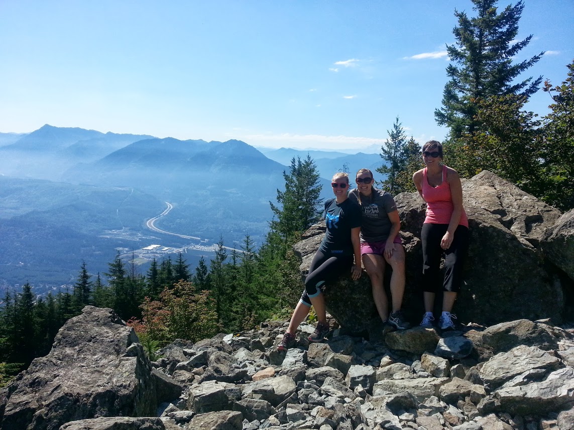
Nous nous sommes assis au soleil et nous nous sommes détendus un moment, en profitant de la vue étendue, de la faune et de la flore, et en prenant quelques collations. Après avoir pris quelques photos pour témoigner de notre exploit, nous avons redescendu la montagne en offrant nos propres encouragements aux randonneurs en route vers le sommet.
Comme la montée nous avait ouvert l'appétit, nous nous sommes arrêtés au North Bend Bar and Grill pour des hamburgers. C'est un bon vieux restaurant de ville natale avec de la bonne nourriture et une atmosphère confortable. Il y a même une cheminée avec un énorme canapé pour s'y installer pendant les mois les plus froids.
Longueur : 4 miles
Élévation : 3,700 feet
Distance pour Seattle Southside : 40 miles
Prenez vos chaussures de randonnée, de l'eau, et éventuellement un imperméable, et sortez avant que le soleil ne disparaisse pour l'hiver.
Vous pourriez également être intéressé par...

Où faire du sport dans le sud de Seattle
Courir, faire du vélo, sauter, s'étirer... il existe une multitude de façons de transpirer dans le sud de Seattle.

Cyclisme urbain : Le meilleur de Seattle Southside
Mettez la pédale... sur la pédale ! Le vélo est un moyen plus écologique et plus sain de se déplacer en ville.

Quatre campings près de Seattle Southside
Vous cherchez à faire du camping près de Seattle ?